Day 5 – Lamar Valley and Mammoth Springs
December 10, 2006
| Today, our last full day in Yellowstone, we planned to visit some of the remaining parts of the park which we had not yet covered (mainly to the north) namely Lamar Valley and Mammoth Hot Springs. | |
| Lamar Valley: I have written more about Lamar Valley in the Yellowstone Wildlife page of this Blog (look right side links). Lamar valley buzzes with activity usually during dawn and in dusk when animals come for feeding. We decided to go to Lamar valley early in morning to beat the crowd as well as enjoy the nature all by ourselves!. | |
| Starting at 5:30 am from our cabin in Canyon area, we drove north towards Tower Roosvelt junction. Make a right here towards the North-East entrance to go to Lamar Valley. |  |
| Lamar Valley is home to herds of elk, bison, and several packs of wolves, making it Yellowstone National Park’s prime location to view wildlife. Lamar Valley yields a breathtaking wide-open landscape scattered with ponds and large boulders. |  |
| Its saturation in natural beauty and wondrous opportunity make Lamar Valley as attractive to tourists as it is to wildlife. You can read more about Lamary valley at Yellowstone Wildife. After spending nearly 3 hours at this beautiful place during which we saw bisons, Grizzly bear, deers and lots of different wildflowers in full bloom, we decided to drive back and visit Mammoth Hot Springs. For this you have to drive back to Tower Roosvelt junction and start driving west to Mammoth Springs. The total distance is around 30 miles from Lamar valley to Mammoth Springs. | |
| Mammoth Hot Springs: Several key ingredients combine to make the Mammoth Hot Springs Terraces: heat, water, limestone, and a rock fracture system through which hot water can reach the earth’s surface.Today’s geothermal activity is a link to past volcanism. A partially molten magma chamber, remnant of a cataclysmic volcanic explosion 600,000 years ago in central Yellowstone, supplies one of the ingredients, heat.Hot water is the creative force of the terraces. Without it, terrace growth ceases and color vanishes. The source of the water flowing out of Yellowstone’s geothermal features is rain and snow. Falling high on the slopes in and around Yellowstone, water seeps deep into the earth. This cold ground water is warmed by heat radiating from the magma chamber before rising back to the surface.Hot water must be able to reach the earth’s surface in relatively large volumes to erupt as a geyser or flow as a hot spring. In Yellowstone, many conduits remain from the collapse of the giant caldera; frequent earthquakes keep this underground “plumbing” system open. Even though Mammoth lies north of the caldera ring-fracture system, a fault trending north from Norris Geyser Basin, 21 miles (34 km) away, may connect Mammoth to the hot water of that system. A system of small fissures carries water upward to create approximately 50 hot springs in the Mammoth Hot Springs area.Another necessary ingredient for terrace growth is the mineral calcium carbonate. Thick layers of sedimentary limestone, deposited millions of years ago by vast seas, lie beneath the Mammoth area. As ground water seeps slowly downward and laterally, it comes in contact with hot gases charged with carbon dioxide rising from the magma chamber. Some carbon dioxide is readily dissolved in the hot water to form a weak carbonic acid solution. This hot, acidic solution dissolves great quantities of limestone as it works up through the rock layers to the surface hot springs. Once exposed to the open air, some of the carbon dioxide escapes from solution. As this happens, limestone can no longer remain in solution. A solid mineral reforms and is deposited as the travertine that forms the terraces. Some of the important points of interest here are: | |
| Lower Terrace overlook :==>
Opal Terrace: Opal Spring flows from the base of Capitol Hill, which is across the road from Liberty Cap. After years of dormancy, this spring became active in 1926 and began depositing up to one foot (0.3m) of travertine per year. |
 |
| In 1947, a tennis court was removed to allow natural expansion of the terrace. Further growth threatens the historic home next to Opal Terrace. Designed by Robert Reamer and built in 1908, the house is an example of Prairie Style architecture. Among Reamer’s other designs are the Old Faithful Inn and the Roosevelt Arch at Yellowstone’s North Entrance. Today sandbags and an earthen wall protect the house. The National Park Service strives to protect both historic and natural resources. At Opal Terrace both types of resources must be considered. | |
| Liberty Cap: This 37-foot (11-m) hot spring cone marks the northern portion of Mammoth Hot Springs. Liberty Cap was named in 1871 by the Hayden Survey party because of its marked resemblance to the peaked caps worn during the French Revolution. Its unusual formation was created by a hot spring whose plumbing remained open and in one location for a long time. Its internal pressure was sufficient to raise the water to a great height, allowing mineral deposits to build continuously for perhaps hundreds of years. | |
| Palette Spring: Water flows from a flat area and then down a steep ridge, creating a colorful hillside palette of brown, green, and orange (the colors are due to the presence of different heat-tolerant bacteria). This effect is much the same as an artist would achieve by allowing wet paint to run down a vertical surface. | 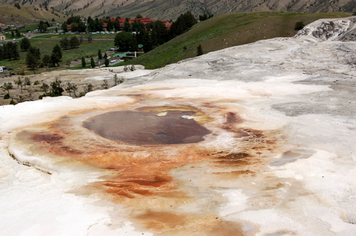 |
| Minerva Terrace: Minerva Spring is a favorite not only because of its wide range of bright colors but also for its ornate travertine formations. Since the 1890s, when records were first kept on the activity of Mammoth Hot Springs, Minerva has gone through both active and inactive |  |
| periods. For several years in the early 1900s, it was completely dry, but by 1951 reports state that Minerva was again active.
During some cycles of activity, water discharge and mineral deposition have been so great that boardwalks have been buried beneath mounds of newly deposited travertine. Consequently, an elevated and movable boardwalk now spans the hill in the vicinity of Minerva. In recent years, hot spring activity has shifted dramatically from Minerva to other features on the Lower Terraces, and back again. |
|
| Jupiter and Mound Terraces: These terraces display cycles of activity typical of Mammoth Hot Springs. In 1937, Mound Terrace was called “the most beautifully colored spring”. Inactive for decades, its weathered travertine shows new |  |
| patterns where chunks of the soft rock have broken or fallen. In the 1980s, jupiter Terrace flowed heavily and overtook boardwalks several times. It has been dry since 1992.If you continue past Mound Terrace, you’ll see the top of Minerva Terrace and possibly the hot spring whose water create Minerva. Additional steps take you to the Upper Terraces, which you can also reach by car.The entrance to the Upper Terrace Drive is 2 miles south of the Albright Visitor Center on the road to Norris. This one way scenic drive winds for 1.5 miles among Hot Springs and travertine formations. | |
| Main Terrace: You can view this large terrace and its colorful springs from several vantage points. To your left, follow the board walk to an overlook of New Blue Sping. One of the best examples of the area’s dynamic character, New |  |
| Blue Spring shifts activity frequently and can become active or inactive several times in one year. It began overflowing to the north in summer 2000. An overlook leads to a view of the entire Main Terrace; at the far side you can see Canary Spring. At the beginning of the trail to Canary Spring, a short spur trail takes you to a view of Cupid Spring, which was active until early 2000. Continue on the trail to benches where you can relax and watch the waters and colors of Main Terrace. | |
| Canary Spring: You’ll find flowing water, new travertine formations, and shade as you walk to Canary Spring. Listen to the cascading water and imagine you were here in late 1880s. At that time yellow filamentous bacteria was prominent. Yellow remains a common color near the vent, and the spring also exhibits the orange, brown, and green seen in the other hot springs of the area. | |
| Prospect Springs: For a few years in the 1990’s, this area was more active next to the road. Travertine formed the distinctive mound in one year. In recent years, most of the activity shifted toward the trees. And it may have shifted again by the time you visit. | |
| New Highland Terrace: Tree skeletons stand as monuments to a landscape created in the 1950s. This area has been inactive since the 1980s. | |
| Orange Spring Mound: This spring flows slowely from several vents at its top. Its striking colors come from the thermophiles living in the hot water. |  |
| Bath Lake: Bath Lake was popular swimming hole until it dried up in 1926. It filled again after the 1959 Hebgen Lake Earthquake and remained a lake through the 1970s. By then bathing in hydrothermal features was illegal because it destroys fragile formations and change their activity. | |
| White Elephant Back Terrace: Water laden with calcium carbonate has flowed from a fissure to build this ridge, which an early tour guide thought resembled the back of an elephant. Activity conctantly shifts here. |  |
| Angel Terrace: The dramatic presence of this feature comes from abundant water, white formations, and colorful thermophiles that thrive in hot water. Angel Terrace was dry and crumbling for decades, but resumed activity in 1985. Some of the other dormant features you have seen on this drive may one day flow again too. Click Here to check the live web cam video from mammoth springs. |
 |
| After seeing the Mammoth Springs, we started our journey south back towards Canyon area Norris Basin, stopping at Virginia Cascades which is a 2 mile diversion on the road between Norris and Canyon Area.Finally we reached our cabin at the Canyon Area, thus ending our 5 day sojurn to the one of the beautiful place in USA – The Yellowstone National Park which will be permanently etched in our memory.Tomorrow we will embark on a long drive to Glacier National Park which is around 450 miles from Yellowstone. | |
Day 4 – Yellowstone Canyon Area.
December 1, 2006
| Today, the plan is to cover the Canyon area of the National park. Since we are just outside the south entrance at Flagg Ranch resorts, the total distance is around 60 miles to the canyon area. As always it is very essential to start your day with the sun so that you can give yourself plenty of time exploring the park and avoid the crowd. | |
| Driving north from South entrance, you would pass through the some of the natural points in West thumb area and Village area. Some of the must see points in Village area are: | |
| Natural Bridge: Located just south of Bridge Bay Campground, it is an easy one-mile walk to the Natural Bridge. There is also a bicycle trail leading to the bridge. The Natural Bridge was formed by erosion of this rhyolite outcrop by Bridge Creek. The top of the bridge is approximately 51 ft. above the creek. A short switchback trail leads to the top, though travel across the bridge is now prohibited to protect this feature. | |
| Fishing Bridge: .5 mile east from the fishing bridge junction in the main road is the fishing bridge. This is a very lively place and you can see people fishing standing on this bridge.The original bridge was built in 1902. It was a rough-hewn |  |
| corduroy log bridge with a slightly different alignment than the current bridge. The existing bridge was built in 1937. The Fishing Bridge was historically a tremendously popular place to fish. Angling from the bridge was quite good, |  |
| due to the fact that it was a major spawning area for cutthroat trout. However, because of the decline of the cutthroat population (in part, a result of this practice), the bridge was closed to fishing in 1973. Since that time, it has become a popular place to observe fish. It is at the location where the Yellowstone River emerges from Yellowstone Lake. After spending some time here, we continued our northward journey to the Canyon area. | |
| LeHardy Rapids: The LeHardy Rapids are a cascade on the Yellowstone River, three miles north of Fishing Bridge. Geomorphologically, it is thought that this is the actual spot where the lake ends and the river continues it’s northward flow. |  |
| In the spring, many cutthroat trout may be seen here, resting in the shallow pools before expending bursts of energy to leap up the rapids on the their way to spawn under Fishing Bridge. The rapids were named for Paul LeHardy, a civilian topographer with the Jones Expedition in 1873. Jones and a partner started off on a raft with the intent of surveying the river, planning to meet the rest of their party at the Lower Falls. Upon hitting the rapids, the raft capsized, and many of the supplies were lost, including guns, bedding, and food. LeHardy and his partner saved what they could and continued their journey to the falls on foot.The rapids became a popular visitor attraction when a boardwalk was built in 1984 providing access to the area. Due to increased visitation, a group of harlequin ducks, which once frequented this area in spring, have not been seen for several years. The boardwalk has consequently been closed in early spring to protect this sensitive habitat, but the harlequins have not returned | |
| Canyon Area: The Grand Canyon of the Yellowstone is the primary geologic feature in the Canyon District. It is roughly 20 miles long, measured from the Upper Falls to the Tower Fall area. Depth is 800 to 1,200 ft.; width is 1,500 to 4,000 ft. The canyon as we know it today is a very recent geologic feature. The present canyon is no more than 10,000 to 14,000 years old, although there has probably been a canyon in this location for a much longer period. The exact sequence of events in the formation of the canyon is not well understood, as there has been little field work done in the area. The few studies that are available are thought to be inaccurate. We do know that the canyon was formed by erosion rather than by glaciation. A more complete explanation can be found in the Geological Overview section. The geologic story of the canyon, its historical significance as a barrier to travel, its significance as destination/attraction, and its appearance in Native American lore and in the accounts of early explorers are all important interpretive points. The “ooh-ahh” factor is also important: its beauty and grandeur, its significance as a feature to be preserved, and the development of the national park idea. | |
| Canyon area tour involves two circuits. The North Rim road and South Rim Road. Both involves some hiking. So allow yourself sufficient amount of time and water to enjoy the diverse features in this area. Click here to see a map of Canyon Rim Drive and Trails |
|
| While you are in the park, educate yourself with all the ranger led tours in the area you plan to visit. It is always a good idea to join a ranger on a guided tour. That way, you learn more about the area you are visiting. We learnt that a ranger led tour of the South rim starts at 3 pm from Uncle Tom’s trail. So we decided to cover the North tim road first and then move down to South rim in the afternoon. Before that we first filled ouself at the cafeteria in the Canyon area. There are lot of choices in the menu to choose. | |
| North Rim Drive: This one way loop road starts at the parking lot of the Canyon area. This loop consists of walks and overlooks that give you a panaromic view of the canyon as well as an upclose view of the uper and lower falls. | |
| Glacier Boulder: Along the road to Inspiration Point there is a house-sized granite boulder sitting in the pine forest alongside the road. It was plucked from the Beartooth Mountains by an early Pinedale Glacier and dropped on the north |  |
| rim of the Grand Canyon of the Yellowstone nearly 80,000 years ago. Continued glacial advances and retreats led to the present-day appearance of the canyon and surrounding area. | |
| Inspiration Point: After the North rim drive becomes one way, make the first left turn. Drive to the end of the road and park. More than 50 steps direct you down this moderately strenuous walk to an overlook and spectacular canyon |  |
| views. Rest on the benches and enjoy the views: halfway down and at the base you can glimpse the lower falls of the yellowstone. From the overlook, you can view the canyon upstream and downstream, watch the acrobatic flights of birds, and smell the sulphur from hydrothermal features far below. | |
| Grandview Point: Stop here for a colorful view of the canyon.(Bear left at the fork in the walkway. the right fork is part of the North Rim trail). You can see the river snaking through the rocks as it rushes downstream. Stop to rest on the benches cut from bolders and listen. |  |
| Lookout and Redrock point: Bear left on this paved trail for your first full view of the Lower Falls. As you scan the canyon, look for osprey nests and signs of hot springs (look for wet, rust-coloredrocks or for stream). Also notice the trail below you. |  |
| Red Rock Trail takes the hardy visitor close enough to feel the spray. To reach this trail from the parking lot, bear right on the paved walkway. The trail drops 500 ft (150 m) in about 3/8 mile. It is not recommended for visitors with heart,lung, or other health conditions. |  |
| Brink of the Lower Falls: Every second, an average of 37,417 gallons of water plunge 308 ft over the Lower Falls. You can experience this power by taking this trail to the brink. Even if you can’t make the full trip (a drop of 600 ft/180m), consider walking part way down for a glimpse of the brink and the upper falls. |  |
| Brink of the Upper Falls: To reach this overlook from North Rim Drive, turn left onto the main road, and then left at the sign. Shorter than the lower falls, Upper falls (109 ft/ 33 m) is impressive in its own way. Soon after you begin |  |
| the short walk, stop at the rocks on the left and listen to the rush of water. Then proceed down the steps and around the corner. You’ll be rewarded with the sight of the colliding currents rushing pellmell over the brink. Bursts of spray often create rainbows in the afternoon. | |
| South Rim Drive: On the South Rim Drive you can view the Upper Falls from two view points at uncleTom’s parking area, Artist points. As planned we reached the Uncle Tom’s parking area at 3 pm to join the ranger led tour of the South rim trail starting at UncleTom trail’s parking area. I would recommend everyone to take this tour as it passes through the some of the most scenic views of the canyon at the same time is also very educative. | |
| Uncle Tom’s trail: For an unparalleled canyon and waterfalls experience, take a deep breath and descend this trail. A series of paved inclines and more than 300 steps lead you about 500 ft down into canyon. Your destination is a platform form which you see, hear and feel the power of the |  |
| Lower Falls. Much of the walk is constructed of perforated steel sheeting, so you should wear comfortable, flat heeled walking shoes. Also watch out for ice in the early morning or in the spring or fall. |  |
| Upper Falls View Point: This easy walk takes you to two viewpoints of the Upper Falls, which drops 109 ft over a lip of volcanic rock. Upstram of the waterfall, you can se the old canyon bridge, which today is part of the North Rim Trail. From the left overlook, you can glimpse Crystal Falls on the far side of the Canyon. |  |
| South Rim Trail: Begin this trail at the Wapiti trailhead on South Rim Drive near Chittenden bridge. This partially paved trail parallels the Canyon and connects the Wapiti Trailhead with Uncle Tom’s parking Area and Artist Point (1-3/4 miles). You’ll wind in and out of forests between striking viewpoints of both falls and the canyon. | |
| Artist Point: When you reach this set of overlooks, you’ll see why this is obe of the most photographed views in Yellowstone. Framed by the Canyon walls with forests for a backdrop, the Yellowstone river thunders more than 308 ft over | 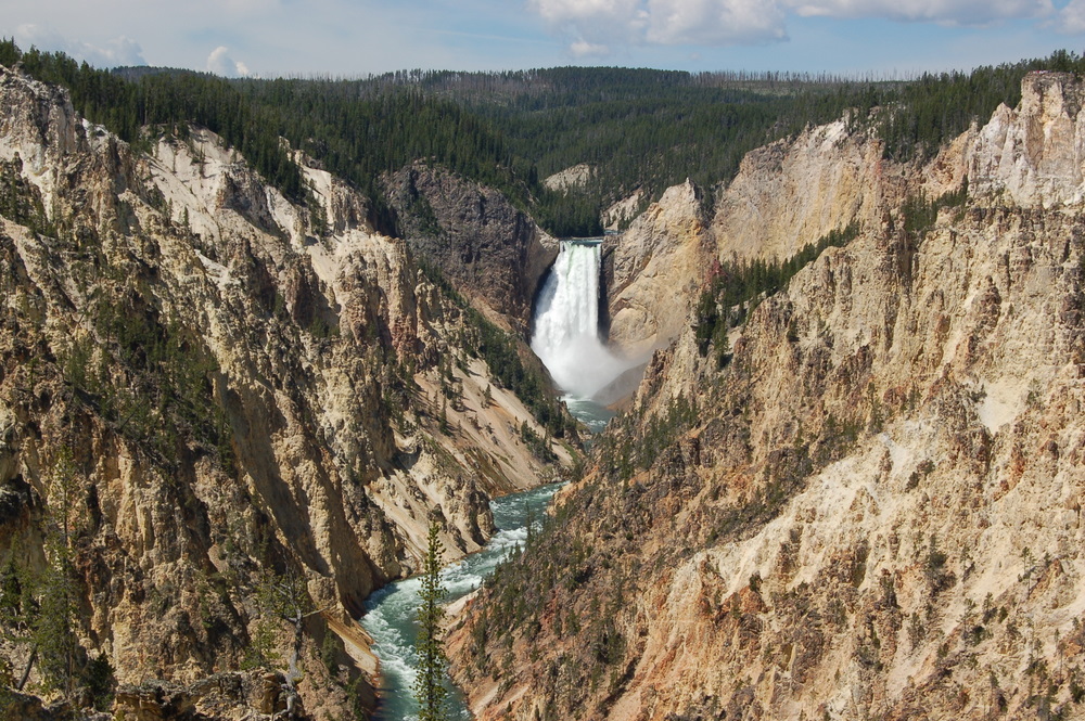 |
| Lower Falls. From the Upper overllook, you can view the Canyon in both directions. Look for Osprey, bald eagles, ravens and swallows. | 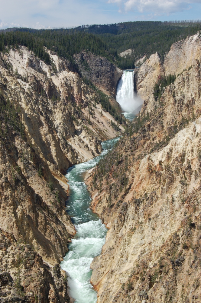 |
| After completion of the South Rim, we decided to drive north towards Tower Roosvelt area. This drive passes through two important viewing points. | |
| Tower Falls: Tower Fall is the most recognizable natural feature in the district. The 132-foot drop of Tower Creek, framed by eroded volcanic pinnacles has been documented by park visitors from the earliest trips of Europeans into the Yellowstone region. Its idyllic setting has inspired |  |
| numerous artists, including Thomas Moran. His painting of Tower Fall played a crucial role in the establishment of Yellowstone National Park in 1872. The nearby Bannock Ford on the Yellowstone River was an important travel route for early Native Americans as well as for early European visitors and miners up to the late 19th century. | |
| Calcite Springs: This grouping of thermal springs along the Yellowstone River signals the downstream end of the Grand Canyon of the Yellowstone. The geothermally altered rhyolite inspired the artist Moran; his paintings of this |  |
| scene were among those presented to Congress in 1872, leading to the establishment of the park. The steep, columnar basalt cliffs on the opposite side of the river from the overlook are remnants of an ancient lava flow, providing a window into the past volcanic forces that shaped much of the Yellowstone landscape. The gorge and cliffs provide habitat for numerous wildlife species including bighorn sheep, red-tailed hawks, and osprey. | |
| Finally, exhausted after the day’s hiking and viewing this natural beauty, we returned back to the Canyon area and retired into our Pioneer Cabin thus ending another wonderful day in Yellowstone. | |
| FYI: Pictures you see in this blog are shot by us during our recent vacation. If you are interested in any of these pictures (original 6 mb), please contact us at bestvacation@gmail.com | |
Day 3 – Grand Teton NP
September 23, 2006
| Today, we decided to savour the splendor of the majestic Grand Teton National park. Since we had one full day in Grand Teton, we decided to see all the important places and also do some moderate hiking without tiring ourselves too much. | |
| As always, we started our day early in the morning and we were out of our cabin at Flagg Ranch by 7 am. After having our breakfast in the Flagg Ranch cafeteria, we visited the visitor center to get some information on the places to visit/hiking trails that we can do during the |  |
| day. I would suggest every body to do some homework beforehand, so that you don’t have to spend more time on deciding what to do?. Click here to see the map of the area. Driving south from Flagg Ranch, our first destination is Colter bay. However the drive itself was breath taking. The road passes along the banks of the jackson lake, with the grand view of the Teton range. | |
 |
 |
| 1. Colter Bay Visitor Center and Indian Arts Museum. | |
| This is the first top in our drive today. Here, you can visit the museum to view art created by native people and get a glimpse of nineteenth-century Native American life. Videotapes about the park and its wildlife are shown throughout the day. Also there is a general store, gas available at this location. Also visit the beautiful colter bay just behind the visitor center. |  |
| 2. Willow Flats / Oxbow Bend. | |
| Next stop is Willow Flats.Turnout, six miles south of Colter Bay for a view of extensive wet lands that provodes excellent habitat for birds, beavers, and moose. Jackson lake, and Mt. Moran the most massive peak in the Teton range, dominate the background. Located one mile east of Jackson Lake Junction, is the Oxbow Bend, another good spot to look for wildlife. | 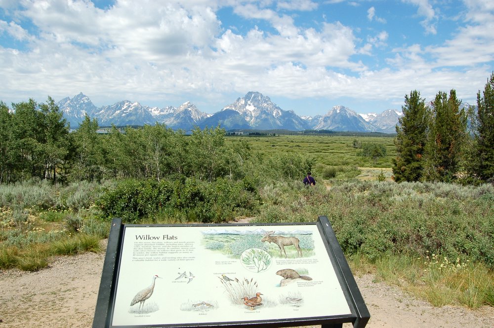 |
| 3. Jackson Lake Dam Overlook. | |
| Jackson lake dam, one mile west of Jackson Lake Junction on the Teton Park Road, raises the level of Jackson Lake a maximum of 39 feet. In addition to being a reservoir, Jackson Lake is also a natural lake formed by an immense glacier that once flowed from the Yellowstone plateau. Park on the south west side of the dam and take a short walk for a peaceful view of kackson lake and Mt. Moran |  |
| 4. Signal Mountain Summit Road. | |
| This 5 mile drive starts one mile south of Signal Mountain Lodge and campground. The road winds to the top of Signal Mountain, 800 fett above the valley. Summit overlooks provide a panoramic view of the entire Teton Range, Jackson Lake, and most of Jackson Hole. The road is narrow and parking at overlooks is limited. Trailers or large motor homes are not permitted. |  |
 |
 |
| 5. North Jenny Lake Junction. | |
| Turn here for a four mile, one-way drive along the shores of beautiful Jenny Lake. This drive runs north to south. Stop at the overlook for excellent views. |  |
| 6. South Jenny Lake / Hidden Falls. | |
| Stop at South Jenny Lake for a hike to Hidden Falls! This hike is five miles round trip, along the lake shore. If you prefer, you can go to the Jenny Lake Marina and take a shuttle boat across the lake. The boat costs $9.00 round-trip for adults and departs every 10-15 minutes between 8am and 6pm. |  |
| We took the boat ride, which was very relaxing and then the hike to hidden falls. This is one of the best and recommended hikes, if you are planning to have a small hiking experience, at the same time enjoying the nature. The hike just to Hidden Falls is 0.8 miles from the boat marinal. It passes through forested area with well marked trails. Stop at different points to enjoy the scenery and the streams that dot the trail. | |
| Hidden Falls: One of the most beautiful falls in the Teton range, is also very refreshing place after a mile long hike. We spent almost half an hour near the falls | |
 |
 |
| Inspiration point: After Hidden Falls, we decided to continue our hike to the next point in the trail, Inspiration point. The trails becomes somewhat difficult after Hidden falls, but it is worth taking up that extra hike. Coz the scenery from this point is really out of this world. With the Teton range to your left towering high into the sky and Jenny lake to your left makes this a wonderful experience. |  |
 |
 |
| 7. Menor’s Ferry/Chapel of the Transfiguration. | |
| Turn off the Teton Park Road 0.5 mile north of Moose. The Menor’s Ferry Trail, less than 0.5 mile long, affords a look at homesteading and pioneer life in Jackson Hole.Visit Bill Menor’s cabin country store. View a replica of the ferry that he built. The altar window of the Chapel of the Transfiguration frames the tallest Teton park. | |
| 8. Antelope Flats Loop. | |
| Turn north at Moose Junction and look for Antelope Flats Road, one mile ahead on the right. Follow this side road along old ranches and abandoned hayfields. Bisons and antelopes are abundant. Also you get some spectacular view of the Teton Range. |  |
| 9. Snake River Overlook. | |
| Stop here at this large turnout for grand views of the Teton Range. This is where Ansel Adams took his spectacular photos of the mountains and the snake river. |  |
| 10. Cunningham Cabin Historic Site. | |
| Take a self guided walk through an old sod-roofed homestead cabin. Look for badgers and coyotes hunting in the nearby meadows. | |
| These are some of the important places you must not miss on your day long drive of the Tetons.If you have extra time to spend in the Tetons, the you should also consider one of these activities.Ranger-led Activities: During summer, join a ranger for a visitor center talk, museum tour, stroll, hike, or evening programs. Attend these activities to learn more about the natural and human history of the park and parkway.Take a Hike: Over 250 miles of hiking trails in the park and parkway range from level and easy trail on the valley floor to steep, arduous trails in the mountains. At visitor centers, ask aranger for recommended hikes and look at, or purchase, maps and trail guides. Also there are lot of private agencies offering rock climbing, mountain hikes accompanied by professional coaches.Raft Trips on the snake River: Park and parkway concessionaires operate trips on the snake river daily in summer. Watch for Moose along the banks and bald eagles and American White pelicans soaring above.Horseback Riding: Park concessionaires offer horse back rides at Colter Bay, Jackson Lake Lodge, and Flagg Ranch. | |
| By the time we finished our last driving attractions, the sun was setting creating a very beautiful ambience. We decided to drive back to our cabin at Flagg Ranch, stopping at as many places as possible to savour the setting sun amongst the Teton Monsters. | |
 |
 |
Day 2 -Yellowstone NP: Geysers
August 8, 2006
| Today the plan is to cover the geyser region of Yellowstone national park. Even though the whole park is a geologically active area, it is the region between Oldfaithful and Norris basin where you see most of the gysers and hot springs.In yellowstone one important tip to beat the crowd is to rise with the sun. Since all the tour buses and visitors start pouring in after 10 am, some of the well known places like Oldfaithful, Artist point can get very crowded. So it is always advisable to visit these places early in the morning to beat the crowd and enjoy the scenery all by yourself.As planned we checked out from room in Grant Village at 6:30 am, had our breakfast at the general store where you can get good breakfast at reasonable rate. | |
| Kepler Cascades: Driving west from Grant Village, the first point of interest that you encounter is Kepler Cascade. This is a beautiful place and with the morning fog and the cascade below, it is really worthwhile spending at least 30 min here. |  |
| Old Faithful Area: We reached the parking lot of Oldfaithful area at 7:30 am (17 miles from Grant Village). The first thing to do is to visit the visitor center and check the eruption timing of all the geysers. Also check out the timing of all the ranger led tours in the area. |  |
| It is always advisable to attend the ranger led programs/tours if available. That is the best way to learn more about the place especially in Yellowstone. We decided to see the South Section (map of south section ) which also includes Oldfaithful geyser in the morning and then come back at 5:30pm to attend the ranger led tour to see all the geysers in the Northen section(map of North section). | |
| Old Faithful Geyser: As I mentioned earlier, it is better to be at oldfaithful geyser early in the morning to beat the crowd. OldFaithful geyser erupts every 90 min. The approx eruption time of all the geysers can be obtained at visitor center. | 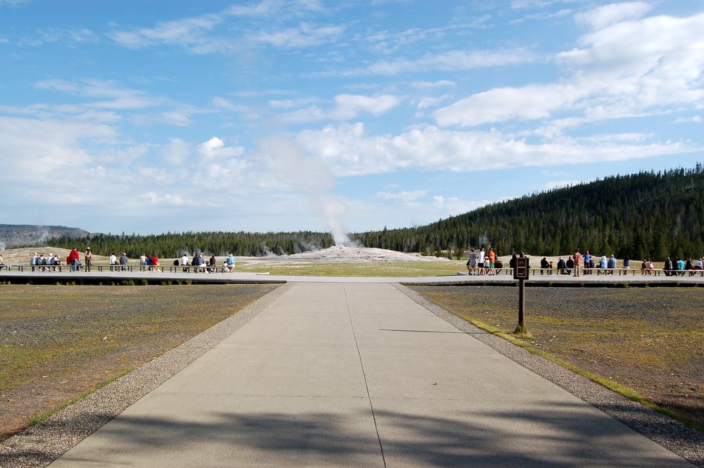 |
| Old Faithful erupts more frequently than any of the other big geysers, although it is not the largest or most regular geyser in the park. Its average interval between eruptions is about 91 minutes, varying from 65 – 92 minutes. An eruption lasts 1 1/2 to 5 minutes, expels 3,700 – 8,400 gallons (14,000 – 32,000 liters) of boiling water, and reaches heights of 106 – 184 feet (30 – 55m). It was named for its consistent performance by members of the Washburn Expedition in 1870. Although its average interval has lengthened through the years (due to earthquakes and vandalism), Old Faithful is still as spectacular and predictable as it was a century ago. | |
 |
The boardwalk near Oldfaithful is very quiet before 8 am and it is very pleasant to walkaround the area with a coffee. Also there are fewer than a dozen people on the Oldfaithful benches and you can enjoy the early |
| post sunrise eruption of the day without rubber-necking for a good view. After watching the geyser, we decided to take a stroll at the boarded Oldfaithful geyser loop which is 0.7 miles long. It is worth taking this hike and in the morning with mist and steam all aroubd, it is very relaxing. List of Trails or walkways from Oldfaithful visitor center
Click here to view live video from Old Faithful Geyser. If you see people standing around, then the geyser might erupt shortly! |
|
| After our small hike, we stopped at the historic OldFaithful inn. Built during the winter of 1903-04, the Old Faithful Inn was designed by Robert C. Reamer, who wanted the asymmetry of the building to reflect the chaos of |  |
| nature. The lobby of the hotel features a 65-foot ceiling, a massive rhyolite fireplace, and railings made of contorted lodgepole pine. Wings were added to the hotel in 1915 and 1927, and today there are 327 rooms available to guests in this National Historic Landmark. | |
| Since we had decided to attend the ranger led tour in the evening to see geysers in the Northern section, we decided to proceed north from Oldfaithful to madison and Norris Basin. On the way, there are lot of points of interest that must be seen. | |
| Biscuit Basin: Three miles north of Old Faithful is Biscuit Basin, named for the unusual biscuit-like deposits formerly surrounding Sapphire Pool. Following the 1959 Hebgen Lake earthquake, Sapphire erupted, and |  |
| the “biscuits” were blown away. Other notable colorful features in the basin are Jewel Geyser, Shell Geyser, Avoca Spring, and Mustard Spring. | |
 |
 |
| Midway Geyser Basin: Next stop is Midway geyser basin. This geyser basin, though small in size compared to its companions along the Firehole River, holds large wonders for the |  |
| visitor. Excelsior Geyser reveals a gaping crater 200 x 300 feet with a constant discharge of more than 4,000 gallons of water per minute into the Firehole River. Also in this surprising basin is Yellowstone’s largest hot springs, Grand Prismatic Spring. This feature is 370 feet in diameter and more than 121 feet in depth. | |
 |
 |
| Excelsior Geyser | Grand Prismatic Spring |
 |
 |
| Bacteria Mat | FireHole River |
| Firehole Lake Drive: Leave the Midway Geyser Basin and continue down the road to Firehole Lake Drive. Take this drive slowly, stopping often and lingering. Since Firehole Lake Drive is a one-way loop, if you want to see something again you must repeat the entire circuit. You will pass Great Fountain Geyser, which is predictable but has a very long interval; pass it by unless someone |  |
| who knows geysers confirms that an eruption is imminent, in which case stick around for the show. The most easily photographed geyser on Firehole Lake Drive is just a few yards down the road: White Dome Geyser. |  |
| It erupts frequently but unpredictably. I think I have waited perhaps 20-30 minutes at most for it to go off. Pink Cone Geyser and Firehole Lake are ahead, the last notable stops on Firehole Lake Drive. | |
| After completing the Firehole Lake Drive, continue down the road to the Fountain Paint Pot area, and walk the boardwalk. You’ll see several geothermal features including a constantly erupting geyser Clepsydra), hot springs and paint pots. |  |
| Firehole Canyon Drive: After completing the Firehole Lake Drive, you can take the Firehole Canyon Drive. This 2 mile drive takes you through the beautiful filehole canyon and you can also stop to see the scenic Firehole Falls. |  |
| Gibbon Falls: Continue on the road to Madison, bear right toward Norris, you will be following the Gibbon River now. You will come to Gibbon Falls after five miles after Madison; it is usually crowded here during midday, perhaps difficult to |  |
| find a parking spot. The view of the falls from the road on the bluff is poor. If you are adventurous, instead do this: park a few hundred yards downriver from the main viewing area, hop over the wall, descend the dirt slope to the river, walk up the river along the fisherman’s trail to the foot of the falls, and enjoy this view. | |
| Once you are done with Gibbon Falls, continue to Gibbon Meadows, which is a broad meadow area about five miles north of Gibbon Falls. The hope here is that you will see elk, they are often in the meadow. If you arrive to a line up of cars, elk are likely the cause of the traffic. If there are elk here, great, stop and admire them while you can. You will likely see more during your visit to Yellowstone but in the event you do not, you want to get a good look now (a bird in hand…). | |
| As you proceed further from Gibbon meadows, you pass through terrace springs, Artists Paintpots(1 mile hike- highly recommended) and finally reach Norris Basin Area. | |
| Norris Basin: Norris Geyser Basin is the hottest, oldest, and most dynamic of Yellowstone’s thermal areas. The highest temperature yet recorded in any geothermal area in Yellowstone was measured in a scientific drill hole at |  |
| Norris: 459°F (237°C) just 1,087 feet (326 meters) below the surface! There are veryfew thermal features at Norris under the boiling point (199°F at this elevation). Norris shows evidence of having had thermal features for at least |  |
| 115,000 years. The features in the basin change daily, with frequent disturbances from seismic activity and water fluctuations. The vast majority of the waters at Norris are acidic, including acid geysers which are very rare. Steamboat Geyser, the tallest geyser in the world (300 to 400 feet) and Echinus Geyser (pH 3.5 or so) are the most popular features. The basin consists of three areas: Porcelain Basin, Back Basin, and One Hundred Springs Plain. Porcelain Basin is barren of trees and provides a sensory experience in sound, color, and smell; a 3/4 mile dirt and boardwalk trail accesses this area.Back Basin is more heavily wooded with features scattered throughout the area; a 1.5 mile trail of boardwalk and dirt encircles this part of the basin. One Hundred Springs Plain is an off-trail section of the Norris Geyser Basin that is very acidic, hollow, and dangerous. Travel is discouraged without the guidance of knowledgeable staff members. The area was named after Philetus W. Norris, the second superintendent of Yellowstone, who provided the first detailed information about the thermal features. | |
| After hiking the two trails in Norris Basin and also a stop at the museum, we decided to head back to the OldFaithful area to take the ranger lead tour of the Oldfaithful geysers starting at 5:30 pm from Castle Geyser. | |
| OldFaithful Geyser Tour: This ranger led tour starts at Castle Geyser and goes all the way till Morning Glory Pool. On the way we pass through some of the most beautifyl pools and geysers. | |
| Castle Geyser: The magnificient cone of Castle Geyser is thousands of years old and rests upon even older platform. Together, they form one of the largest sinter formations in the world. Castle’s eruption pattern has changed throughout |  |
| its recorder history; it is currently erupting about every 13 hours. A water eruption frequently reaches 75 feet and lasts about 20 min, followed by a noisy steam phase of 30-40 min.its recorder history; it is currently erupting about every 13 hours. A water eruption frequently reaches 75 feet and lasts about 20 min, followed by a noisy steam phase of 30-40 min. | |
| Crested Pool: With temperatures above 199 deg F (93 deg C), Crested Pool is almost constantly boiling, sometimes to 8 feet or more. The extreme heat prevents most bacterial growth, resulting in exceptionally clear blue |  |
| water. Boiling is perticularly active along the intricate sinter formation circling the spring, the “crested edge”. Listen to the sizzling. | |
| Grand Geyser: If you see a crowd at Grand Geyser and the pool looks full, wait awhile. You might get lucky and see the tallest predictable geyser in the world erupt. A classic fountain geyser, |  |
| Grand erupts with powerful bursts rather than a steady column like Old Faithful. An average eruption lasts 9-12 minutes and consists of 1-4 bursts, sometimes reaching 200 feet. | |
| Beauty Pool: shows its brightest colors when its water is hottest. When the water is cooler, as it has been rescently, earth toned thermophiles thrive. Beauty is closely related to neighboring Chromatic Pool. During periodic |  |
| energy shift, the level of one spring rises as the other descends. | |
| Giant Geyser: This Geyser was dormant for many years after an energy shift in 1955. Since then, it has slowely become active again. During 2005, it erupted 10 times. Its spectacular eruption last |  |
| about an hour and can reach 250 feet. In between and during eruptions, smaller geysers on the same sinter platform may erupt. | |
| Daisy Geyser: Walk up the hill to Daisy Geyser, where you will find a good view of the geyser basin- and may be a close view of this geyser’s eruption.Daisy erupts at an angle to a height of 75 feet for 3-5 minutes. Daisy is usually |  |
| predictable, with eruption intervals of 120-210 minutes. An exception to this is when nearby Splendind Geyser erupts, although this occurs rarely and unpredictably. | |
| Grotto Geyser: A popular performer, Grotto Geyser erupts about every seven hours and splashes 10 feet for 1.5 to more than 10 hours. The weirdly shaped cone may have resulted from sinter covering the tree that once grew here. |  |
| Riverside Geyser: Situated on the bank of the Firehole River, Riverside Geyser is one of the most picturesque and predictable geysers in the park. During its 20-minute eruptions, a 75-foot |  |
| column of water arches gracefully over the river. Eruptions are about six hours apart. Watch for water flowing over the edge of the cone beginning 75-120 minutes before an eruption. Look for rainbow in its spray. | |
| Morning Glory Pool: Long a favoured destination for park visitors, Morning Glory Pool was named in the 1880s for its remarkable likeness to its namesake flower. Since that time, this blue pool has fallen victim to vandalism, people have |  |
| thrown tons of coins, trash, rocks and logs into the pool. Much of this debris became embedded in the sides and vent of spring, which reduced the water circulation and thur the water temperature. Orange and yellow bacteria, which can grow in the cooler water, now spread toward Morning Glory’s center. | |
That was the end of the tour and we trecked back to the Oldfaithful cafeteria  for our dinner. This cafeteria closes at 9 pm. So it is very essential to plan ahead. After dinner, we spent sometime savouring the bluish ambience at the OldFaithful which looked wonderful, before starting on our drive to Flagg Ranch Resorts, which is 2 miles south of South Entrance. It was well past 11 pm by the time we checked into our cabin and went to bed thinking of our second memorable day in Yellowstone. for our dinner. This cafeteria closes at 9 pm. So it is very essential to plan ahead. After dinner, we spent sometime savouring the bluish ambience at the OldFaithful which looked wonderful, before starting on our drive to Flagg Ranch Resorts, which is 2 miles south of South Entrance. It was well past 11 pm by the time we checked into our cabin and went to bed thinking of our second memorable day in Yellowstone. |
|
Day1
August 5, 2006
| Day 1: We reached Billings at noon(late by 1 hour). Billings airport is small and can be bit crowded when planes land simultaneously. It took us 45 min to finally get a car and come out of the airport.( Fortunate enough to get a free upgrade to infinity G35). Finally we started driving west from billings (90 w) at 1:30 pm. Destination was Grants Village Yellowstone via Beartooth Highway. There are two ways to reach Yellowstone from Billings. One way is to drive west on 90 and take 89 south to north entrance of YNP. Other one is to drive through the Beartooth Highway (212) to reach the north-east entrance of YNP. Total distance approx 200 miles. Going west on 90, take US-212 exit 434 to Laurel/Red Lodge. This is a two lane highway but speed limit is 70 mph. Nothing much is on the way until you reach Red Lodge.Red Lodge lies near the eastern end of the scenic byway. This small mountain resort community is tucked into Rock Creek Valley at 5,555 feet elevation. There are festivals and celebrations to enjoy, interpretive nature trails, and cross-country and alpine skiing opportunities. A number of competitions, such as the Peaks to Prairie Triathlon and the Beartooth Run, attract athletes and spectators. The downtown is pleasant, with nice shops. | ||||||||||
| Beartooth Highway: The most scenic drive of this highway is between Red Lodge and Cooke city. As we continued our drive, the scenery started unfolding before our very eyes. Arguably this is the most beautiful drive we have ever passed through. The snow clad peaks, clear lakes and the wild flowers that dot these meadows take you to a totally different world which is so pristine, quiet and |  Beartooth Highway |
|||||||||
| beautiful. This is one of the beautiful view you get as you drive through this road. Below is few pictures of the meadows that you pass.I hope these pictures would atleast give you an idea as to what you can expect on the drive. Click here to see more pictures from beartooth mountain drive. | ||||||||||
|
||||||||||
| It took us almost 3 hours to cover a distance of 68 miles between Red Lodge and CookeCity with numerous stops on the way. We reached the north-east entrance of Yellowstone at 5:30 pm. Our final destination for the day was Grants Village which is near the south entrance (see map). This 82 miles drive within the park took us through tower falls,canyon, Hayden valley ,lake area.Although it was a long drive, it was definitely worth it. Since it was still |  North-East entrance of YNP |
|||||||||
| bright (sun sets at 9:45 pm here), we decided to see at least couple places on the way (so that we don’t have to visit those places again). The fist stop was at Lamar valley. Even though I had planned to come here later in the trip, we did stop at few places to see bison grazing in the evening sun. Next stop was near canyon, to see an elk grazing along the road side. | ||||||||||
| Hayden Valley: The most beautiful place on the way was Hayden valley. This is 10 miles south of canyon junction and with the evening sun lighting up the valley from the west, the scenery was just picture perfect. We stopped here for almost 30 min savouring the natural beauty. | ||||||||||
 |
 |
|||||||||
| Hayden Valley | Hayden Valley 2 | |||||||||
| Mud Volcano: Our next stop was Mud Volcano area. This is one of the most geologically active area with lot of thermal activity. Click here to read more about Mudvolcano and Hayden Valley. |  Mud volcano |
|||||||||
| Grant Village: Finally we reached Grant village at 8 pm . It was indeed a long day which began at 3:30 am in the morning. We registered at the Grant Village visiting center and checked into our room. At $115 per night, it is a modest lodge with no AC, but the facilities are good. Read more about Grant Village at Grant Village . | 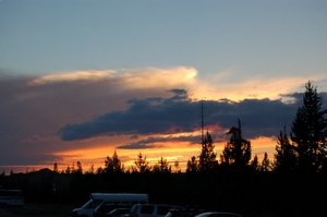 Evening sky in Grant village |
|||||||||
| We had our dinner at the lake village restaurant, located right next to the Yellowstone lake. It is a nice restaurant with good menu choice (Click here to see the menu at Grant Village restaurant). After dinner, we decided to attend the ranger led program at the Grant village amphitheatre, but we had to beat a hasty retreat to escape from the mosquitoes (bug repellent is a must). | ||||||||||


Planning
July 31, 2006
July 2006 will be etched in our memory for a very long time to come coz. the first ten days of this month was spent in one of the most memorable vacations of our life. During the course of our vacation, we got to drive through Beartooth highway, arguably one of the most scenic drives in US and visit some of the most beautiful and diverse national parks in US like Yellowstone, Grand Teton and the magical Glacier National parks.
This is a small attempt to bring out the beauty and serenity of these places and also help those of you planning a visit in near future.
IDEA: All this began on a cold February morning when both I and my wife were watching a program in discovery channel showing sunrise in “Lamar Valley” inside yellowstone. The beauty and silence of the place instantly hooked us to Yellowstone and that was when we decided to visit Yellowstone. As I started researching more on yellowstone, the more curious I was to learn about the different features of the park and also the facilities available there. Initially the idea was to drive to Yellowstone from St Louis, MO, stay there for 5 days and then drive back. All my readings suggested that I would need atleast 5 days to cover both the Yellowstone and Grandteton NP. However on further research I found that since Glacier National Park is only 450 miles from Yellowstone, it would be wise to cover even that park and to reduce time, I decided to fly to Billing, Montana. This way, I will also get an opportunity to drive through BearTooth highway to Yellowstone. So the final plan was to fly to Billings and then drive to Yellowstone through Beartooth Highway.We would spend 5 nights in Yellowstone area, drive to Glacier National park,spend 3 days there and then drive back to billings before flying back to STL.
Preparations: After planning, the next task is to start preparations. The first thing I finished was booking flight ticket to Billings. Since there are only limited flights to billings ( Frontier,United and NorthWest flies to Billings), it would be wise to finish booking at least 2-3 months in advance or else the price could climb very fast. After flight next comes accommodations.
All accommodations within Yellowstone is managed by Xanterra Parks and Services (http://www.travelyellowstone.com/). There are couple of important points to be noted here.
1. Since accommodations within the park are limited, they tend to get booked very early in the season. If you are planning to visit the park in summer ( July-august), I would recommed you to book your accommodations at least by March/April.
2.In YNP, accommodations are available in Canyon, Lake Village, Grant Village, OldFaithful area, Mammoth and tower Roosevelt area.( http://www.nps.gov/yell/planvisit/orientation/index.htm) . Before booking your room, plan which area you would cover in a day and then book accordingly. This way, you could avoid driving long distance at the end of the day just to get to your room.
In all of these areas, you could find different kinds of accommodations ranging from campground to log cabins to normal lodges. I don’t think any of these rooms have AC, but I don’t think you would need AC since it cools down at night.
In Grand Teton, you would find few resorts inside the park. We stayed at Flagg Ranch resorts which is just outside YNP (2 miles from south entrance). Lodging link can be found in nps.gov. http://www.nps.gov/grte/planyourvisit/lodging.htm
In Glacier National Park, you can find lodges inside the park http://www.glacierparkinc.com/default.asp. Also affordable accommodations can be found outside park both near west entrance (west glacier) or near east entrance (St Mary). We stayed at the Historic Tamarack Lodge which is 8 miles from the west entrace (5 min to the park). I found it very affordable with all the amenities and free breakfast (http://www.historictamaracklodge.com/index.html). I will be explaining in detail about these places in later posts.
If you are planning to fly to Billings, you also need to rent a nice car (V6 would be very helpful). Try to search for a deal with unlimited mileage. I was lucky enough to find one such deal from Alamo. Later on most of the companies set a maximum limit of 1500 miles. That can be bit less if you are planning to cover all the 3 NP. Alamo, Enterprise, Hertz and Budget have their counters right at the baggage claim area in the airport.
Almost all the activities in these parks are outdoors. So prepare yourself adequately. Hiking shoes will be of great help. Light clothes, bug sprays, sun screens and sunglasses are a must especially if you are planning to visit during summer. Temperature during our stay ranged between 60-90 deg during day and cooled down to 40-60 at night. A good camera (telephoto lens will be of great help) and a pair of binoculars is a must.
